May 18-20th had shown some potential for several days, but looked somewhat iffy early on before looking fairly good as the days approached. The trigger was pulled on Friday, May 17th when I found out I would be able to partner up with local based chasers Adam Lucio and Danny Neal. The chase on May 18th was only my second chase day of what was a slow season thus far.
We departed Chicago around 1AM Friday night/Saturday morning, set for the marathon drive to West-Central Kansas. The initial target area was just north/east of Dodge City, KS. We made it out to Greensburg, KS in the early afternoon hours of Saturday. After doing a little driving around the area figuring out where we wanted to sit, we decided to set up shop at a gas station on the west side of Greensburg. This location eventually became willed with the many chasers that were out and about, which allowed me to meet up with some familiar faces...along with some new ones.
After sitting around for a while, a CU field developed to our west along the dry line. With a cap in place nothing too interesting happened for a while, but eventually a few cells did develop a push north...eventually becoming severe and tornadic. Even with this, we decided not to pursue them as more development was expected farther south in a better environment. After sitting around for a little longer more development started to occur to our west and southwest, as the cap continued to weaken. Now was the fan part...Which storms do we go after? Adam wanted to head north to the initial development from earlier, which was now well to our north. Danny wanted to play some of the middle activity, which was to our west. I wanted to stay put and wait to see what activity moving north out
of Oklahoma was going to do. After going back and forth for a while, we decided to make a play on the middle activity, which by now had pushed off to our WNW. When made it to the cell in a short time...It appeared to be struggling and didn't look great on radar, so we quickly decided to head south to make a play on the severe storms that had pushed put of N. Oklahoma and now into S. KS. We had driven about a mile or two south at most when all of a sudden numerous reports of funnel clouds started to come out, from the middle storm we had just left. Looking a bit better on radar, we quickly turned back around and back north to make a play on it...Which ended up being a good decision.
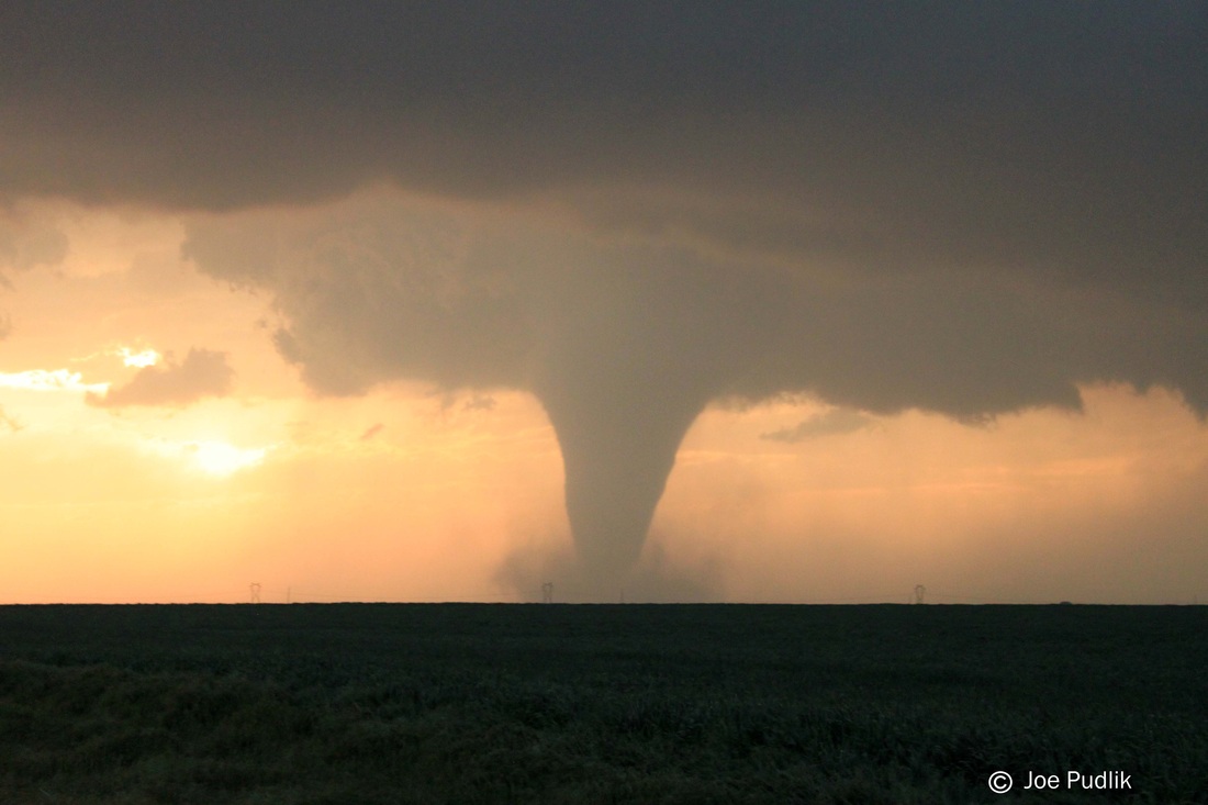
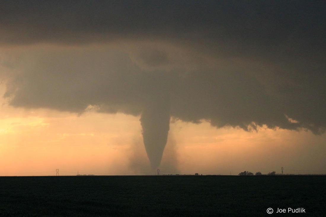
Driving north several miles, we finally were able to get a good view of what now was a nice supercell storm. The base of the storm was somewhat high, but this would change. We pulled off on a side road off of highway 183, to the
northwest of Kinsley, KS where we had a great view. The storm's base continued to be high, but started to lower with defined rotation starting to show up to our west. A persistent funnel cloud quickly formed, and eventually touched down. After this point, the tornado stayed on the ground for over 20 minutes, taking on many shapes, as it was back-lit by the lowering evening sun. We never had to move, as we were in perfect position to see the full life cycle of this tornado, which was rated and EF-4 based of DOW radar data. This tornado eventually lifted and we started to head northeast to get into position for another tornado.
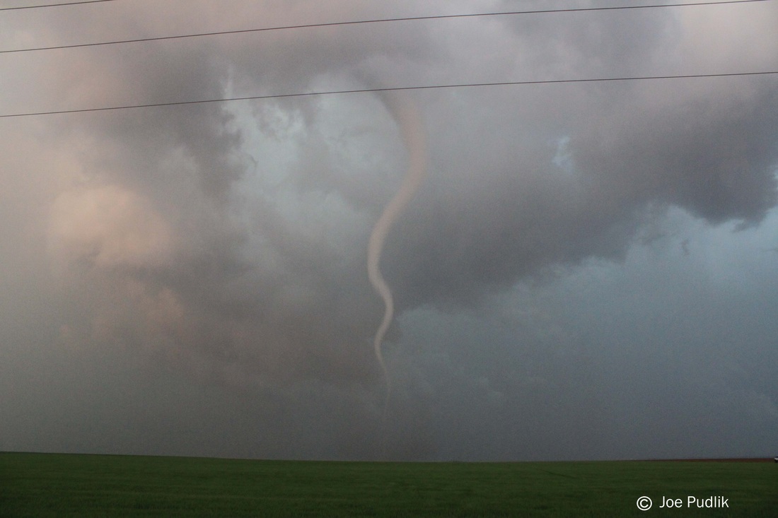
Driving a short bit north and having trouble with police and DOW blocked roads, we sat on highway 183 and watched as another tornado formed and drift around in a field to our east. This time with the setting sun to our west and
the tornado to our east, it made for another back-lit display. After watching the tornado for several minutes, it started to occlude and back up towards us. With no east/west options available, we had to head north, but not before a close call with what was now a rope tornado. After getting a bit north we stopped once again where we witnessed a very long and roped out tornado, as it continued to the WNW under mammatus filled skies, before weakening.
We ended up calling it a chase at this point, as activity had started to from into a solid line. We ended up heading to Great Bend, KS for the night, where we met up with several other chasers for a quick dinner before shacking up for the night.
There were a few firsts for me on this chase...
These were my first tornadoes of the 2013 season, and the first in over a year (4/14/2012). This was the first time I had gotten clean/tripod-ed video of a tornado from start to finish. The first tornado, which was rated and EF-4, was
the strongest I had witnessed up until this point.
Some pictures and video from this chase can be viewed below. Additional pictures can be found in the 2013 photography section and additional videos can be found in the 2013 video section.
We departed Chicago around 1AM Friday night/Saturday morning, set for the marathon drive to West-Central Kansas. The initial target area was just north/east of Dodge City, KS. We made it out to Greensburg, KS in the early afternoon hours of Saturday. After doing a little driving around the area figuring out where we wanted to sit, we decided to set up shop at a gas station on the west side of Greensburg. This location eventually became willed with the many chasers that were out and about, which allowed me to meet up with some familiar faces...along with some new ones.
After sitting around for a while, a CU field developed to our west along the dry line. With a cap in place nothing too interesting happened for a while, but eventually a few cells did develop a push north...eventually becoming severe and tornadic. Even with this, we decided not to pursue them as more development was expected farther south in a better environment. After sitting around for a little longer more development started to occur to our west and southwest, as the cap continued to weaken. Now was the fan part...Which storms do we go after? Adam wanted to head north to the initial development from earlier, which was now well to our north. Danny wanted to play some of the middle activity, which was to our west. I wanted to stay put and wait to see what activity moving north out
of Oklahoma was going to do. After going back and forth for a while, we decided to make a play on the middle activity, which by now had pushed off to our WNW. When made it to the cell in a short time...It appeared to be struggling and didn't look great on radar, so we quickly decided to head south to make a play on the severe storms that had pushed put of N. Oklahoma and now into S. KS. We had driven about a mile or two south at most when all of a sudden numerous reports of funnel clouds started to come out, from the middle storm we had just left. Looking a bit better on radar, we quickly turned back around and back north to make a play on it...Which ended up being a good decision.
Driving north several miles, we finally were able to get a good view of what now was a nice supercell storm. The base of the storm was somewhat high, but this would change. We pulled off on a side road off of highway 183, to the
northwest of Kinsley, KS where we had a great view. The storm's base continued to be high, but started to lower with defined rotation starting to show up to our west. A persistent funnel cloud quickly formed, and eventually touched down. After this point, the tornado stayed on the ground for over 20 minutes, taking on many shapes, as it was back-lit by the lowering evening sun. We never had to move, as we were in perfect position to see the full life cycle of this tornado, which was rated and EF-4 based of DOW radar data. This tornado eventually lifted and we started to head northeast to get into position for another tornado.
Driving a short bit north and having trouble with police and DOW blocked roads, we sat on highway 183 and watched as another tornado formed and drift around in a field to our east. This time with the setting sun to our west and
the tornado to our east, it made for another back-lit display. After watching the tornado for several minutes, it started to occlude and back up towards us. With no east/west options available, we had to head north, but not before a close call with what was now a rope tornado. After getting a bit north we stopped once again where we witnessed a very long and roped out tornado, as it continued to the WNW under mammatus filled skies, before weakening.
We ended up calling it a chase at this point, as activity had started to from into a solid line. We ended up heading to Great Bend, KS for the night, where we met up with several other chasers for a quick dinner before shacking up for the night.
There were a few firsts for me on this chase...
These were my first tornadoes of the 2013 season, and the first in over a year (4/14/2012). This was the first time I had gotten clean/tripod-ed video of a tornado from start to finish. The first tornado, which was rated and EF-4, was
the strongest I had witnessed up until this point.
Some pictures and video from this chase can be viewed below. Additional pictures can be found in the 2013 photography section and additional videos can be found in the 2013 video section.
| Chase Statistics: Tornadoes: 2 Wind: 40-50MPH Hail: None | SPC Severe Weather Reports: 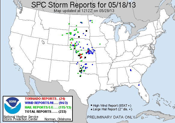 |
 RSS Feed