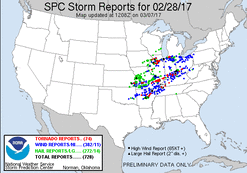
This day had shown potential of being an early season severe weather event for a big portion of the Central U.S. for several days preceding it, and it ended up coming to fruition. There appeared to be two areas of higher potential, with the northern one being across the heart of Illinois, and the other being in the vicinity of the Mississippi River/Ohio River area. The northern play was my only viable option to chase, and was nice to see being closer to home for the first event of the season, an early one at that.
My target area for the day was in W. and C. Illinois, near and just south of I-80. Storms were initially expected to develop late in the afternoon, with early sunset being a potential issue as well as fast storm motions. As the day of progressed, it became clear storm initiation would occur earlier, during the mid-afternoon. Storms indeed ended up developing earlier, with initiation in E. Iowa during the mid-afternoon hours. These storms quickly became discrete as they pushed ENE into NW and W. Illinois.
We left DeKalb a bit later than I wanted, as storms were already moving into the Moline to Galesburg to Macomb areas. We were heading south on I-39 towards La Salle, when one of the lead supercells became tornado warned down that way. We approached from the north driving into portion of the core, experiencing 40mph+ winds and penny sized hail. Unfortunately due to traffic, we fell behind the storm a bit, and got onto I-80 as the storm was moving towards Ottawa. At this point I had to make the decision to continue trying to catch-up to this storm we had been following, or down south the the far southern severe storm, that had nothing around it to mitigate its potential as it matured. The decision was made to continue with our current storm, and we quickly became stuck in traffic once again just NW of Ottawa as a tornado was in progress just a few miles to our SE. We ended up getting out of traffic, making a quick jump trough the non-damaged north side of Ottawa where we got on Route 6. Still behind the storm and trying to catch up, the winding Route 6 along the Illinois River made it difficult to catch up, but we finally did as we approached Morris. At this time we caught a glimpse of the lowering, and potentially the end of the Marseilles tornado. Getting into Morris we decided to drop off this storm, as rotation was weakening and it was heading into he more populated metro area shortly.
From there, we decided to head SW to the other tornadic supercell in the area. We ended up intercepting the storm near Ransom, IL. By this time this storm was was showing signs of weakening as well, and we let it pass us by. Well after dark at this point with no other decent looking storms around, we called it a chase and headed home.

 RSS Feed