Following a great chase the previous day, Saturday(14th) had great potential with a high risk issued for portions of the Plains.
My chase partner and myself left Oklahoma City mid morning and made it up to the our general target area east of the dryline, in the Hutchinson/Pratt, KS area by early afternoon. There had already been some severe development to our west, which pushed northeast. A second round and what would become the main show quickly developed behind this initial round of activity, from around Dodge City, KS down into the far NE. Texas Panhandle. Several discrete supercell formed, and we decided to jump on one that was headed in the general direction of Greensburg, KS.
We made it to this, our first supercell on the day as it was moving towards the west side of Greensburg. It had decent structure, but looked to be a bit outflow-ish. We follow it for a bit as it headed north of Greensburg, but we decided to drop off of it as it appeared to be weakening a bit and is still looked to have outflow-ish issues. At this point a second tornado warned supercell had quickly developed off to our southwest, west of Greensburg, and we decided to head it's way.
We made it to this second supercell as it was passing on the northwest side of Greensburg. Like the first cell, it seemed to look a bit outflow-ish and started to weaken a bit. With that, we decided to drop south the the next supercell down the line, which was southwest of Pratt, KS. These first two supercells that we dropped off of ended up merging into a single supercell and produced several photogentic tornadoes as it pushed northeast, eventually up through the Salina, KS area.
We made it down to our third supercell on the day as it was passing near Pratt, KS. Like our first two cells on the day, this storm looked decent for a time when we first arrive on it. As we followed it northeast towards the Arlington, KS area it quickly started to weaken. With the demise of this cell, we decided to drop south to the next supercell in line, which was southwest of Pratt, KS.
We made it to this, our fourth supercell on the day as it passed northwest of Kingman, KS, while we were positioned just east of Penalosa, KS. We were sitting on a side road off of Route 14 when we observed a brief tornado touchdown off to the west, west of Penalosa, KS. We continued to follow this storm northeast into the Arlington, KS area, but it quickly weakened. With the demise of this storm we decided to once again drop back south to the next supercell in line, south of Pratt, KS.
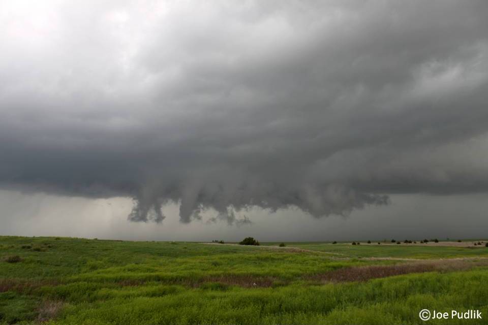
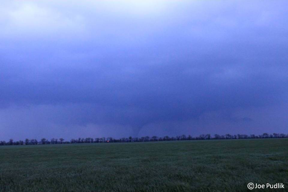
We made it to this next supercell(Our 5th on the day) as it was pushing through the southeast side of Pratt, KS. There had already been reports of two brief tornado touchdowns near Sawyer, KS, off to the south of Pratt. We followed this storm as it progressed northeast and observed a brief tornado touchdown off to our west, as we sat on Route 17 looking west towards the open fields north of Kingman. Continuing to follow the storm northeast, we observed two more brief touchdowns, which were in the vicinity of Pretty Prairie and Castleton, KS. Following the storm as it pushed north of Haven and Burton, KS another tornado touched down in the distance, off to our northeast. Even though it was dusk, a nice cone tornado was clearly visible with a few power flashes being seen as it pushed through Moundridge, KS at the time. According to NWS Wichita surveys, this was only a brief touchdown. After passing through some tree filled areas and low hills, we had a nice trunk/stove pipe tornado off to our north. This tornado eventually would be obscured from our view. As we continued to follow the storm northeast on Route 56 E/N there was another tornado reported. At this point it was dark, but the great lightning show occurring helped show off a well defined wall cloud to our north. We possibly had a brief glimpse of a funnel or tornado, but given were unsure whether it was or not, we just went with what we knew for sure...wall cloud. We ended up staying with this storm for a while longer as it continued northeast, slowly weakening along the way. Eventually we dropped off of it and headed to Topeka, KS for the night.
This was another chase with a few "firsts" for me. This was my first Kansas chase and tornado, and this was my first successful high risk chase(1/3). This ended up being another great chase, with 6 tornadoes observed. It took five supercells to do it, but we finally were able to get on the right one that would have consistent strength and was able to produce multiple times.
Some pictures and video from this chase can be viewed below. Additional pictures can be found in the 2012 photography section.
My chase partner and myself left Oklahoma City mid morning and made it up to the our general target area east of the dryline, in the Hutchinson/Pratt, KS area by early afternoon. There had already been some severe development to our west, which pushed northeast. A second round and what would become the main show quickly developed behind this initial round of activity, from around Dodge City, KS down into the far NE. Texas Panhandle. Several discrete supercell formed, and we decided to jump on one that was headed in the general direction of Greensburg, KS.
We made it to this, our first supercell on the day as it was moving towards the west side of Greensburg. It had decent structure, but looked to be a bit outflow-ish. We follow it for a bit as it headed north of Greensburg, but we decided to drop off of it as it appeared to be weakening a bit and is still looked to have outflow-ish issues. At this point a second tornado warned supercell had quickly developed off to our southwest, west of Greensburg, and we decided to head it's way.
We made it to this second supercell as it was passing on the northwest side of Greensburg. Like the first cell, it seemed to look a bit outflow-ish and started to weaken a bit. With that, we decided to drop south the the next supercell down the line, which was southwest of Pratt, KS. These first two supercells that we dropped off of ended up merging into a single supercell and produced several photogentic tornadoes as it pushed northeast, eventually up through the Salina, KS area.
We made it down to our third supercell on the day as it was passing near Pratt, KS. Like our first two cells on the day, this storm looked decent for a time when we first arrive on it. As we followed it northeast towards the Arlington, KS area it quickly started to weaken. With the demise of this cell, we decided to drop south to the next supercell in line, which was southwest of Pratt, KS.
We made it to this, our fourth supercell on the day as it passed northwest of Kingman, KS, while we were positioned just east of Penalosa, KS. We were sitting on a side road off of Route 14 when we observed a brief tornado touchdown off to the west, west of Penalosa, KS. We continued to follow this storm northeast into the Arlington, KS area, but it quickly weakened. With the demise of this storm we decided to once again drop back south to the next supercell in line, south of Pratt, KS.
We made it to this next supercell(Our 5th on the day) as it was pushing through the southeast side of Pratt, KS. There had already been reports of two brief tornado touchdowns near Sawyer, KS, off to the south of Pratt. We followed this storm as it progressed northeast and observed a brief tornado touchdown off to our west, as we sat on Route 17 looking west towards the open fields north of Kingman. Continuing to follow the storm northeast, we observed two more brief touchdowns, which were in the vicinity of Pretty Prairie and Castleton, KS. Following the storm as it pushed north of Haven and Burton, KS another tornado touched down in the distance, off to our northeast. Even though it was dusk, a nice cone tornado was clearly visible with a few power flashes being seen as it pushed through Moundridge, KS at the time. According to NWS Wichita surveys, this was only a brief touchdown. After passing through some tree filled areas and low hills, we had a nice trunk/stove pipe tornado off to our north. This tornado eventually would be obscured from our view. As we continued to follow the storm northeast on Route 56 E/N there was another tornado reported. At this point it was dark, but the great lightning show occurring helped show off a well defined wall cloud to our north. We possibly had a brief glimpse of a funnel or tornado, but given were unsure whether it was or not, we just went with what we knew for sure...wall cloud. We ended up staying with this storm for a while longer as it continued northeast, slowly weakening along the way. Eventually we dropped off of it and headed to Topeka, KS for the night.
This was another chase with a few "firsts" for me. This was my first Kansas chase and tornado, and this was my first successful high risk chase(1/3). This ended up being another great chase, with 6 tornadoes observed. It took five supercells to do it, but we finally were able to get on the right one that would have consistent strength and was able to produce multiple times.
Some pictures and video from this chase can be viewed below. Additional pictures can be found in the 2012 photography section.
| Chase Statistics: Tornadoes: 6 Wind: 40-50MPH Hail: None | SPC Severe Weather Reports:  |

 RSS Feed