Leading up to this day, it had shown the potential to have quality severe t'storm activity and potentially be chase worthy. One of the biggest concerns, even as the day was unfolding, was the potential for two rounds of activity. If the first round of activity did occur, the question was... What impacts would it have one the second round of activity, which was the main focus for the day?
Prior to heading out chasing during the late morning/midday, I had decided my target would be on the Illinois side of the Mississippi River in far Western Illinois, just south of the Quad Cities metro area. While activity was likely to initially develop and move across SE. Iowa and NW. Missouri, I really didn't want to mess with river crossing issues along the Mississippi River, nor would I make it out there in time to chase that area. I left home with a friend a bit late, in the early afternoon, with sights set on my target area. While heading west, the first round of activity, which developed in the hours prior, really became fairly widespread as it lifted northeastward across my target area and surrounding areas. The second round of activity had already developed and was organizing/maturing across S. Iowa and N. Missouri. Upon making it into the east side of the Quad Cities metro area and stopping for food and gas, we watched as the second/main round of activity, which consisted of supercell t'storms, became severe and tornado warned in SE. Iowa and NW. Missouri. While that was nice to see, what wasn't nice to see was that just downstream, the first round of activity was lingering, leaving little space between rounds for recovery.
We continued our travels southwestward into far Western Illinois, south of the Quad Cities metro, around the Aledo, IL, area, just as the severe/tornado warned supercell t'storms were approaching to our west along the Mississippi River, and were now in view. Unfortunately, as the activity crossed the Mississippi River it felt the effects of a less recovered environment between rounds of activity, and it lost all tornadic potential. Some of the activity did remain severe, however. We intercepted one of the former supercell t'storms, which was now a severe t'storm warned line segment, while on I-280 on the south side of the Quad Cities metro. We encountered gusty winds <40MPH and pea size (0.25") hail with this severe t'storm. After letting this initial severe t'storm pass, we got in to position just south of Colona, IL, to intercept the next severe t'storm approaching. This severe t'storm brought gusty winds <40MPH and up to nickle size (0.88") hail. Following this severe t'storm to the northeast on I-88, we encountered a few bouts of 40-50MPH downburst winds and a few more occurrences of pea size (0.25") hail. We got back ahead of the severe t'storm around the Morrison/Lyndon, IL, area on I-88 and pulled off at an exit briefly. Just as we did so, the severe t'storm interacted with an outflow boundary and briefly showed a bit of weak visual and radar rotation. Just after this, a very large and well organized gustnado developed in a field to our northwest, along the leading edge of the northeastward moving severe t'storm. This gustnado lasted for one to two minutes as it moved across several fields. At this point, sunset had arrived, and the remaining activity in the area was not worth continuing the chase for, so we called it a day and headed home.
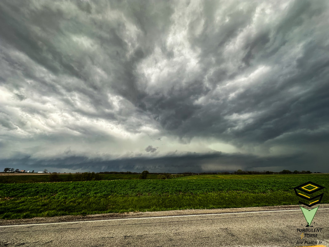
Some pictures from this chase can be viewed below.
Prior to heading out chasing during the late morning/midday, I had decided my target would be on the Illinois side of the Mississippi River in far Western Illinois, just south of the Quad Cities metro area. While activity was likely to initially develop and move across SE. Iowa and NW. Missouri, I really didn't want to mess with river crossing issues along the Mississippi River, nor would I make it out there in time to chase that area. I left home with a friend a bit late, in the early afternoon, with sights set on my target area. While heading west, the first round of activity, which developed in the hours prior, really became fairly widespread as it lifted northeastward across my target area and surrounding areas. The second round of activity had already developed and was organizing/maturing across S. Iowa and N. Missouri. Upon making it into the east side of the Quad Cities metro area and stopping for food and gas, we watched as the second/main round of activity, which consisted of supercell t'storms, became severe and tornado warned in SE. Iowa and NW. Missouri. While that was nice to see, what wasn't nice to see was that just downstream, the first round of activity was lingering, leaving little space between rounds for recovery.
We continued our travels southwestward into far Western Illinois, south of the Quad Cities metro, around the Aledo, IL, area, just as the severe/tornado warned supercell t'storms were approaching to our west along the Mississippi River, and were now in view. Unfortunately, as the activity crossed the Mississippi River it felt the effects of a less recovered environment between rounds of activity, and it lost all tornadic potential. Some of the activity did remain severe, however. We intercepted one of the former supercell t'storms, which was now a severe t'storm warned line segment, while on I-280 on the south side of the Quad Cities metro. We encountered gusty winds <40MPH and pea size (0.25") hail with this severe t'storm. After letting this initial severe t'storm pass, we got in to position just south of Colona, IL, to intercept the next severe t'storm approaching. This severe t'storm brought gusty winds <40MPH and up to nickle size (0.88") hail. Following this severe t'storm to the northeast on I-88, we encountered a few bouts of 40-50MPH downburst winds and a few more occurrences of pea size (0.25") hail. We got back ahead of the severe t'storm around the Morrison/Lyndon, IL, area on I-88 and pulled off at an exit briefly. Just as we did so, the severe t'storm interacted with an outflow boundary and briefly showed a bit of weak visual and radar rotation. Just after this, a very large and well organized gustnado developed in a field to our northwest, along the leading edge of the northeastward moving severe t'storm. This gustnado lasted for one to two minutes as it moved across several fields. At this point, sunset had arrived, and the remaining activity in the area was not worth continuing the chase for, so we called it a day and headed home.
Some pictures from this chase can be viewed below.
| Chase Statistics: Tornadoes: 0 Wind: 40-50MPH Hail: 0.88" (Nickel Size) | SPC Severe Weather Reports: 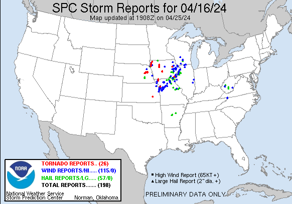 |
 RSS Feed