For several days leading up to this day, severe t'storms looked possible, including the potential for a local storm chase. One of the big questions heading into the day of would be; how much of a time gap there would be between early morning debris activity and the main afternoon round of activity. This time gap would play a role in determining the quality of the environment that would develop. Timing of the main afternoon round of activity also was of focus for myself, as I would be at work until 2PM. In the end, timing was sufficient for an favorable environment to develop and for widespread severe t'storms to occur.
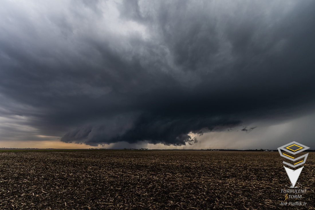
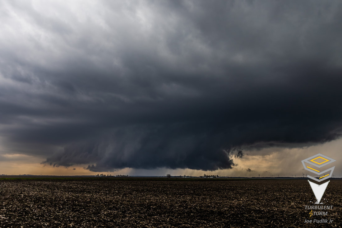
During the early afternoon, initiation occurred along a pre-frontal trough moving across Central Illinois. As this activity moved northeastward, it was very slow to mature, which played in my favor not being able to leave work until 2PM. By 2PM activity had become stronger and more organized, and I made the decision to race southward to make a play on it. After an approximately 1 hour and 30 minute drive, I was approaching a supercell t'storm that was located a distance WSW of Dwight, IL. At this time the supercell t'storm had some rotation and was newly severe t'storm warned. Watching the storm while sitting between Mazon and Dwight, IL, it featured a wall cloud and some visible rotation. Moving northeastward with the storm towards Coal City, IL, the wall cloud had diminished and any visible rotation had ended was limited to within the supercell t'storm on radar. Continuing to follow the supercell northeastward up to I-55 and the far southwestern suburbs of Chicago, I decided to end the pursuit of the supercell t'storm, as it would soon be heading deeper into the urban Chicago metro area.
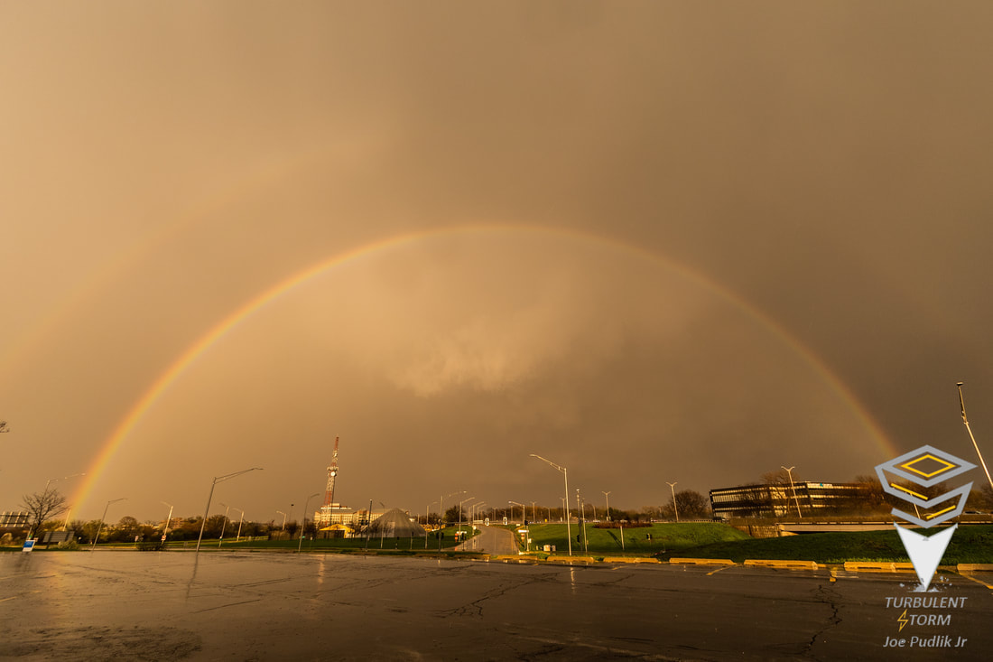
After ending the pursuit of the aforementioned supercell t'storm, I sat in Lorenzo, IL for a while, watching a new round of t'storms develop ahead of the main cold front now moving into the area. This activity steadily matured and organized, and became severe t'storm warned. I ended up heading westward toward Morris, IL to make a play on the new approaching activity. I made it to Morris in time to find a nice spot north of town, to sit and watch what was now a broken line of severe t'storms move in. After messing around with this activity for a bit, it was clear the best tornado and supercell t'storm threat had ended for the day, so I called the chase for the day.
Some pictures from this chase can be viewed below. Additional pictures can be found in the 2022 photography section.
During the early afternoon, initiation occurred along a pre-frontal trough moving across Central Illinois. As this activity moved northeastward, it was very slow to mature, which played in my favor not being able to leave work until 2PM. By 2PM activity had become stronger and more organized, and I made the decision to race southward to make a play on it. After an approximately 1 hour and 30 minute drive, I was approaching a supercell t'storm that was located a distance WSW of Dwight, IL. At this time the supercell t'storm had some rotation and was newly severe t'storm warned. Watching the storm while sitting between Mazon and Dwight, IL, it featured a wall cloud and some visible rotation. Moving northeastward with the storm towards Coal City, IL, the wall cloud had diminished and any visible rotation had ended was limited to within the supercell t'storm on radar. Continuing to follow the supercell northeastward up to I-55 and the far southwestern suburbs of Chicago, I decided to end the pursuit of the supercell t'storm, as it would soon be heading deeper into the urban Chicago metro area.
After ending the pursuit of the aforementioned supercell t'storm, I sat in Lorenzo, IL for a while, watching a new round of t'storms develop ahead of the main cold front now moving into the area. This activity steadily matured and organized, and became severe t'storm warned. I ended up heading westward toward Morris, IL to make a play on the new approaching activity. I made it to Morris in time to find a nice spot north of town, to sit and watch what was now a broken line of severe t'storms move in. After messing around with this activity for a bit, it was clear the best tornado and supercell t'storm threat had ended for the day, so I called the chase for the day.
Some pictures from this chase can be viewed below. Additional pictures can be found in the 2022 photography section.
| Chase Statistics: Tornadoes: 6 Wind: None Hail: None | SPC Severe Weather Reports: 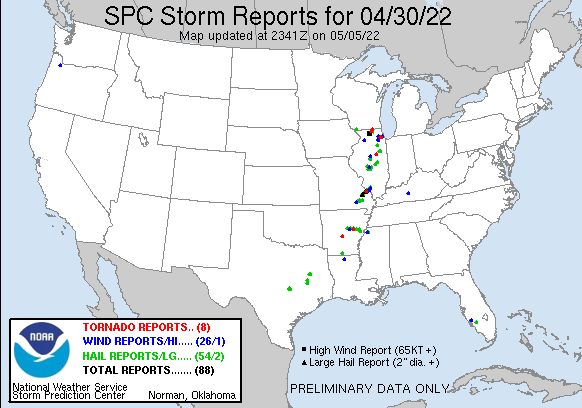 |
 RSS Feed