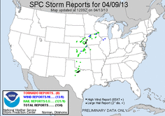
My chase partner and myself had been watching the potential for a multi-day period of severe weather for several days. Unfortunately due to work obligations Tuesday April 9th would be the only day we would be able to chase. We booked a round trip flight to OKC, which would allow us a full days chase. Sitting several days out, there were a few different potential target areas, but as time went on the dryline is SW. OK/N. TX, ahead of the southwestward moving cold front looked to be the best play.
We left Chicago/ORD Tuesday morning and arrived in OKC around 10:30AM. Looking over data on the way to pick up a rental car we saw the cold front moving in from the northwest was well ahead of schedule and already pushing towards the E.Texas/W. Oklahoma border. We picked up the rental car and a quick lunch, and quickly hit the road to our initial target area of Lawton, OK. We made it to Lawton by early afternoon, by which time the cold front was already pushing through W. Oklahoma. Sitting in Lawton for over and hour we watch a capped cumulus field develop around our area and to the south. There were a few attempts at storm initiation across N. TX, but storms were developing behind the front and quickly faded. Around mid-afternoon the cold front started to approached, thus we decided to head south towards Burkburnett, TX.
After making it to Burkburnett, TX we sat there for a short time before noticing a cell developing to our WSW along the cold front. We started to make the drive towards it when it quickly became undercut by the cold front and
started to fade away. On our was back towards Burkburnett we noticed the CU field had diminished across the area and to the north, thus we decided to call it a chase. There was still a CU field to the south, but it was clear that the
cap was preventing any development ahead of the front/along the dryline and that any initiation that occurred was along/behind the front and didn't pose any real chase potential.
On our way back to OKC we decided to make a stop in the Wichita Mountains outside of Lawton for a photo op. On our way up we passed the cold front and watched our temperatures fall from the mid-80's to the 50's. While driving through the mountains a few post frontal storms developed. We encountered high winds, heavy rain, small hail, graupel and melted hail/graupel...and temps fell even more, down into the upper 40's. From there we shot a few pictures and continued back to OKC for dinner and the night, until our flight back to Chicago in the morning. During the overnight and early morning hours several rounds of storms moved through, some which produced small hail.
Event though the chase was a disappointment and didn't produce any real chase action, it was nice to get out there again for the first time since 4/14/12 and it was interesting to see the drastic change in weather as we headed to the Wichita Mountains on the way back, as well as the hail at that time and the storms during the night/early morning.

 RSS Feed