This day was one that looked interesting from several days out. As time went on and the day approached it looked good enough to give it a go and chase. As with every other chase though this season, there were several potential issues including an early day MCS, outflow boundary issues, among other things.
Adam Lucio and myself left the Chicago area shortly after 3AM early Tuesday morning. We made it into Nebraska and picked an initial target of St. Paul, NE by early afternoon. Sitting in St. Paul for a while, fellow chaser/photographer Matthew Cumberland met up with us. While sitting at this location a severe warned supercell, which eventually further developed into a line, moved northwest-southeast off to our northeast. These storms sent out and OFB, which started to push southward across a good portions of northern Nebraska. After sitting around for a few hours, there were signs of initiation trying to occur just to our west. We made the quick decision to head northwest to get on any potential developing storm. While heading west out of St. Paul this initial attempt at development failed, but a storm that had developed along the OFB to the northwest had quickly become a supercell and was tornado warned. This storm was moving slowly east, thus we headed north to make a play on the storm.
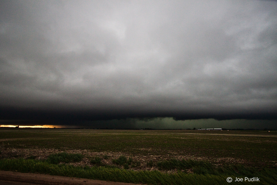
We made it to and got a good visual on the tornado warned storm as we entered the Greenly, NE area. Visually the storm didn't look that great, and appeared to be outflow dominant. Heading north and the east towards Spalding, NE we entered the "bears cage" of the storm. At this point the storm had started to dive southeast, and we started to stair-step southeast with it, eventually making it to near Archer, NE. During the time we were stair-stepping southeast we encountered strong winds, several periods of severe sized hail, and some interesting motions. After making it to Archer we headed east on route 92 where we got out ahead of the storm and was able to stop a few times for pictures. During this time we also witnessed a long lived and large gustnado. After continuing east for a while ahead of the storm it was clear the storm had pass east of a westward moving outflow boundary, ending any good tornado threat, thus we decided to drop south out of Wahoo, NE to make one last play on the storm and get into the hail core. The storm hit once again while we sat in Ceresco, once again producing several hail, but the largest hail of 2.00"+ ended up passing a few miles to our north. After the storm started to pass we decided to call it a chase and head towards Omaha for dinner. After dinner we decided to just grab a hotel instead of driving back overnight on no sleep through an MCS which covered most of Iowa.
Some pictures and video from this chase can be viewed below. Additional pictures can be found in the 2014 photography section.
Adam Lucio and myself left the Chicago area shortly after 3AM early Tuesday morning. We made it into Nebraska and picked an initial target of St. Paul, NE by early afternoon. Sitting in St. Paul for a while, fellow chaser/photographer Matthew Cumberland met up with us. While sitting at this location a severe warned supercell, which eventually further developed into a line, moved northwest-southeast off to our northeast. These storms sent out and OFB, which started to push southward across a good portions of northern Nebraska. After sitting around for a few hours, there were signs of initiation trying to occur just to our west. We made the quick decision to head northwest to get on any potential developing storm. While heading west out of St. Paul this initial attempt at development failed, but a storm that had developed along the OFB to the northwest had quickly become a supercell and was tornado warned. This storm was moving slowly east, thus we headed north to make a play on the storm.
We made it to and got a good visual on the tornado warned storm as we entered the Greenly, NE area. Visually the storm didn't look that great, and appeared to be outflow dominant. Heading north and the east towards Spalding, NE we entered the "bears cage" of the storm. At this point the storm had started to dive southeast, and we started to stair-step southeast with it, eventually making it to near Archer, NE. During the time we were stair-stepping southeast we encountered strong winds, several periods of severe sized hail, and some interesting motions. After making it to Archer we headed east on route 92 where we got out ahead of the storm and was able to stop a few times for pictures. During this time we also witnessed a long lived and large gustnado. After continuing east for a while ahead of the storm it was clear the storm had pass east of a westward moving outflow boundary, ending any good tornado threat, thus we decided to drop south out of Wahoo, NE to make one last play on the storm and get into the hail core. The storm hit once again while we sat in Ceresco, once again producing several hail, but the largest hail of 2.00"+ ended up passing a few miles to our north. After the storm started to pass we decided to call it a chase and head towards Omaha for dinner. After dinner we decided to just grab a hotel instead of driving back overnight on no sleep through an MCS which covered most of Iowa.
Some pictures and video from this chase can be viewed below. Additional pictures can be found in the 2014 photography section.
| Chase Statistics: Tornadoes: 0 Wind: 55-65MPH Hail: 2.00" (Hen Egg Size) | SPC Severe Weather Reports: 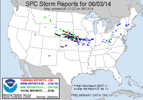 |


 RSS Feed