Heading into this day, it appeared a decent severe threat and potential chase day was likely. The significance of the potential would revolve around an early day MCS, associated trailing OFB and potential capping.
I ended up heading out to make a play on an OFB area turned triple point across NW/NC. IL, with a cold front sliding southeast. The environment in this area was nice...With high CAPE, pooling of moisture with ~70F DP's and good shear. A stronger surface wind flow was lacking, however. I left around mid afternoon and made it out to Rochelle, IL by late afternoon. I sat in Rochelle for a while with CU bubbling along the OFB/triple point just to the west. A storm quickly went up and tried to beat the cap, going severe and up to around ~55k tops within 15 minutes or so. I quickly headed WSW to make a play on this storm and reached it just west of Amboy, IL, but it quickly died shortly after. Ended up calling it a chase at that point, with activity further west near the IL/IA border having little to no tornado threat, and also struggling against the cap.
I ended up heading out to make a play on an OFB area turned triple point across NW/NC. IL, with a cold front sliding southeast. The environment in this area was nice...With high CAPE, pooling of moisture with ~70F DP's and good shear. A stronger surface wind flow was lacking, however. I left around mid afternoon and made it out to Rochelle, IL by late afternoon. I sat in Rochelle for a while with CU bubbling along the OFB/triple point just to the west. A storm quickly went up and tried to beat the cap, going severe and up to around ~55k tops within 15 minutes or so. I quickly headed WSW to make a play on this storm and reached it just west of Amboy, IL, but it quickly died shortly after. Ended up calling it a chase at that point, with activity further west near the IL/IA border having little to no tornado threat, and also struggling against the cap.
| Chase Statistics: Tornadoes: 0 Wind: None Hail: None | SPC Severe Weather Reports: 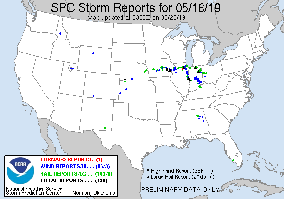 |
 RSS Feed