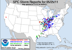
This was a high risk day, though it did not pan out as it could have. Most of the tornadoes on this day were QCLS tornadoes, most of the discrete cell did not produce.
Me and my chase partner made it to an initial chase target of Litchfield, IL by mid-afternoon, as a line of tornadic cell developed in East-Central Missouri. We played a few different cell around Litchfield and southwest around St. Louis, all of which quickly weakened. We then made a play on one of the last discrete cells remaining on the Illinois side of St. Louis. This cell produced softball sized hail in St. Louis (which we missed by less than a mile), but we did end up with a wall cloud and a brief needle funnel cloud in Pontoon Beach, IL. This cell was quickly overtaken by a developing QCLS.
We then decided to race east on I-64 and make a play an a developing discrete cell in southeast Illinois. It quickly became tornado warn as we intercepted it near Enfield, IL. We encountered winds of around 60mph on the north side of the cell, before finally getting on the south side as we approached Carmi, IL. We then followed this supercell northeast up Route 1, the whole time it had a nice lowering/wall cloud. The cell was finally overtaken by the QCLS as we entered Mount Carmel. The QCLS ended up producing 60-70mph winds which brought down numerous tree branches and knocked out power to the part of town we were in.
This was a decent chase and we were on the right cells, but they just didn't produce.

 RSS Feed