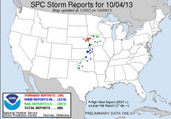
Many had been watching this day well in advance as a possible chase day. Heading into the day models were struggling at first with the exact placement and timing of the system, but eventually came to agreement the day
before the event. All ingredients were in place, including moisture and instability, which are many times a question mark this far north at this time of year. The biggest concerns were the possibility of lingering cloud and convective debris from the previous night’s storms, storm initiation timing and frontal speed. In the end none of the possible concerns ended up being a significant issue.
I ended up partnering up with Adam Lucio and a friend of his. We left his house around 3:30AM with sights set on the NE/IA border area. Usually with a chase in that area you wouldn't expect so early of a start, but models had been trending west/slower with the system, thus we wanted ample time to reach our destination and additional "wiggle room" to move around if needed. On our way out to the target area we started out the day with a "pre-chase".
Interesting severe warned elevated storms greeted us on I-80 east of Des Moines. These storms had some nice structure. One of the storms which was just south of I-80 looked interesting enough for us to make a detour south to take a look at it. The storm had some interesting structure, a lowering for a time and penny sized hail.
We then continued west and made it to Council Bluffs by late morning, where we grabbed some food and sat for a bit. We then decided to make a jump north to Missouri Valley, IA. We sat at this location for a brief time before deciding to head west towards a developed agitated CU field. While heading west a few storms started to develop just ahead of the cold front, and near the warm front. The storms struggled for a time, but eventually started to
mature. A storm near Stanton, NE looking interesting and we decided to make a run at time. While closing in on the storm a second storm had developed immediately to its south, and both showed some rotation. As we approached the storms the northern storm had a wall cloud, as did the southern one. We took a jog south to make a play on the southern storm, but it started to weaken and ended up being ingested by the more dominant northern storm. We make the quick turn-around and jumped back north on some side roads, eventually making it to the north/south Route 15, which goes through Wayne, NE. Driving northward a rain-wrapped tornado quickly developed off to our
west. As we continued north the tornado quickly grew in size, and quickly approached. Our initial plan was to get ahead and north of it, giving us a nice view. The forward speed and width of the tornado didn't allow that happen
though. We ended up having to throw it in reverse as we were not going to make it north before it hit. While in the process of moving back south we ended up getting caught in the outer part of the circulation and low level inflow, which blew out the back window and ripped a rain guard off the driver’s side window. We ended up watching the tornado pass and pull away to the northeast. We ended up making a quick drive west to the nearest town to make a quick patch for the back window.
While in the process of making the fix two new tor warned cell were close to us, one to the north moving over the same areas affected by the previous storm we were on, and another was to our east pushing across the Missouri River. We decided to hit the road again and make a play on the northern cell, which was a bit closer. We made it to this cell as it pushed towards the SD border, west of Sioux City. The storm had a lowering, but it wasn't doing much and it was going to push across the Missouri River and into a more populated area, so we dropped off of it. We then continued east on Route 20 to try and make a play on the far eastern tor warned cell. Along the way we crossed the damage path of the Moville/Correctionville EF-4 tornado, which hit just a short time before we made it there. We eventually were able to get even with the storm, but ended up calling it a chase after the other storm development started to make things messy. We ended up meeting up with several others in Fort Dodge, IA for a celebratory dinner, before hitting the road for home.
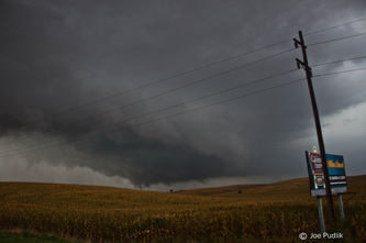
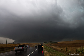
Some pictures and video from this chase can be viewed below.


 RSS Feed